- Government Registration No: 179974/074/075
- PAN No: 606828891
- Tourism License No: 2499


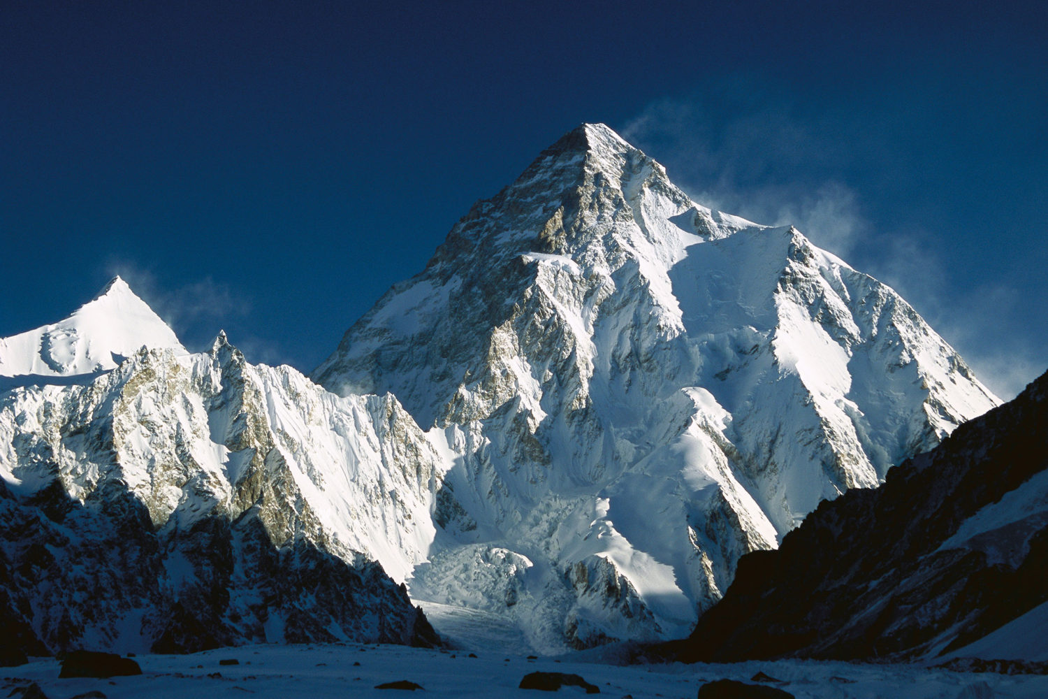
K2 Expedition (8,611m)
K2 EXPEDITION
K2, also known as Chogori, Qogir, Ketu, Kechu, and Mt. Godwin-Austen, stands as the second-
highest mountain in the world at 8,611 meters above sea level. This awe-inspiring peak is renowned for its extreme challenges, earning the title “Savage Mountain” due to the immense difficulty of reaching its summit. The fatality rate among climbers ranks second highest among all peaks exceeding 8,000 meters.
Located on the border between Pakistan and China, K2 has been conquered far fewer times than Mount Everest. Climbers primarily ascend from the Pakistan side, where multiple routes exist. Statistics reveal that 78 percent of successful summit attempts occur via the South-Side route. The remaining climbers navigate the North, East, or West Ridge, the Southwest Pillar known as the Magic Line, the South Face referred to as the Polish Line, or the Northwest Face and Ridge.
The Abruzzi Spur, also called the Normal Climbing Route, follows the North Ridge. No recorded ascent has been made on the East Face, as the difficulty level remains insurmountable according to Pakistan government records.
For decades, winter expeditions proved impossible. This changed in January 2021 when a team of ten Nepalese climbers successfully reached the summit, marking the first winter ascent. Prior to this historic achievement, K2 was the final unclimbed eight-thousander during the winter season.
K2 lies in the Karakoram Range, partly within China’s Xinjiang Uygur Autonomous Region and within the Pakistani-administered Gilgit–Baltistan region. The main summit is positioned between Baltistan and northern Pakistan.
Unlike other famous peaks, this mountain does not offer an easy climb. Considered one of the most formidable challenges in mountaineering, it was long believed to be unconquerable. The number of successful ascents remained remarkably low for years.
The trek to K2’s base camp is significantly more demanding than the Everest Base Camp trek on the southern side. The journey extends over twice the distance, primarily across glaciers and loose rock. Unlike Everest, no villages or lodges exist along the route, making self-sufficiency crucial. Expeditions must transport camp equipment daily, relying on porters to move towards the base camp.
The Abruzzi Ridge in Pakistan stands among the Himalayan classic routes. The British first surveyed K2 in 1856, yet no attempts were made to climb it until 1902. The first serious expedition occurred in 1909, led by the Duke of the Abruzzi, a notable mountaineer. Success eventually came on July 31, 1954, when an Italian team, led by A. Desio, placed Lino Lacedelli and Achille Compagnoni on the summit.
Climbing K2 demands exceptional experience and preparation. The ascent presents constant objective hazards, which shift throughout the season. Only mountaineers with previous 8,000-meter peak climbing experience qualify for an attempt.
K2’s precise coordinates place it at 35°52′57″N, 76°30′48″E. The Advanced Base Camp (ABC) is positioned at 5,305 meters or 17,400 feet. Most expeditions establish four additional camps:
– Camp I at 6,060 meters or 19,881 feet
– Camp II at 6,700 meters or 21,981 feet
– Camp III at 7,250 meters or 23,786 feet
– Camp IV at 7,700 meters or 25,262 feet
Space remains extremely limited, particularly at Camp I and Camp II, which accommodate a maximum of seven to eight tents. Arriving late in the climbing season increases the likelihood of sharing tents with fellow climbers. Unlike Everest or Cho Oyu, K2 remains far less crowded.
Mountaineers consider this the most difficult mountain to climb.
Success requires extensive preparation, proper equipment, and unmatched expertise. Those unprepared for the challenge face severe consequences, as K2 offers no mercy to the inexperienced.
WHY K2 STANDS OUT
K2 remains a top destination for trekkers, hikers, explorers, and mountaineers due to the unparalleled challenge it presents. Few climbing expeditions and trekkers attempt the mountain each year, increasing its appeal for those seeking a unique and less-traveled adventure. Recognized as one of the most breathtaking and formidable mountains in the world, K2 rises 8,611 meters above sea level, making it the second-highest peak on Earth.
Weather plays a significant role in the difficulty of climbing K2. Conditions in the region shift unpredictably, making it nearly impossible to anticipate favorable climbing windows. Isolation, extreme weather, fierce winds, towering height, and the technical demands of the ascent contribute to its allure. The persistent danger of avalanches and rockfalls further intensifies the risks associated with climbing this monumental peak.
Both K2 and Everest experience severe cold, high winds, and frequent storms. However, K2’s climate is far more unpredictable and unforgiving. Rapid weather changes occur without warning, leaving climbers exposed to sudden storms. The summit window is significantly shorter compared to Everest, with only a few days in late July or early August available for summit attempts. On Everest, climbers have greater flexibility, with summit windows in May and October.
K2 THE ULTIMATE TEST FOR MOUNTAINEERS
Professional climbers are drawn to K2 by the sheer difficulty of scaling its steep, treacherous slopes. Avalanches and rockfalls remain a constant hazard on both K2 and Everest. However, the frequency and intensity of such events on K2 surpass those on Everest. The mountain’s unstable terrain collapses easily under its own weight or due to sudden temperature shifts and strong winds.
The Bottleneck section is one of the most perilous parts of the climb. Positioned beneath a massive ice serac, this section poses a serious threat, as the ice can break off at any moment. In 2008, an ice avalanche in this area tragically claimed the lives of 11 climbers. While Everest also experiences avalanches and rockfalls, they tend to occur at lower altitudes or along less congested routes, reducing their overall impact.
Climbing K2 remains a test even for the most experienced and technically skilled mountaineers. The mountain’s triangular shape presents a relentless, near-vertical climb with no easy passages. Steep, slick rock surfaces demand complete concentration. The terrain is among the most technical and unforgiving in the world.
TRAVEL DOCUMENTS NEEDED
- Valid Passport
- Credit Cards
- Pp Size Photo (4 Pieces)
- Insurance Paper And Contact Address.
- Family Members / Company’s Contact Address
TREK FACTS IN DETAIL
Region: Karakoram Range, Gilgit-Baltistan, Pakistan – located on the Pakistan–China border, K2 is the second-highest mountain in the world and one of the most challenging peaks to climb.
Duration: 50–60 Days including arrival, trekking to Base Camp, acclimatization rotations, summit attempt, and return.
Difficulty Level: Extremely Challenging / Technical – suitable only for highly experienced mountaineers with prior 7,000m and preferably 8,000m peak experience.
Maximum Altitude: 8,611 meters (28,251 ft) – Summit of K2.
Trek Style: Full camping expedition. The approach trek to K2 Base Camp is fully tented, passing through the Baltoro Glacier. All higher camps are also fully supported with expedition tents.
Meals: Full-board meals during the entire expedition period. Freshly prepared meals at Base Camp by professional cooks; high-altitude meals provided during summit rotations.
Group Size: 1–15 Persons
Small groups ensure personalized service and better acclimatization.
Best Seasons:
☀️ Summer season only – Late June to August, when weather conditions in the Karakoram are relatively stable for summit attempts.
Accommodation:
Hotel accommodation in Islamabad before and after the expedition; fully tented camping during trekking and climbing phases, including dining, kitchen, and communication tents at Base Camp.
PERMIT REQUIREMENTS
Official K2 Climbing Permit issued by the Government of Pakistan
Trekking permit for the Baltoro Glacier region
Environmental and liaison officer fees (as required by Pakistani authorities
Mandatory registration with local authorities
- Highlights
- Cost
- FAQ
- Riding Gear
- Fixed Departure
Summit K2 (8,611m), the world’s second-highest and most technically challenging mountain
Located in the remote Karakoram Range, offering breathtaking glacier and peak scenery
Trek across the famous Baltoro Glacier, passing Concordia and other iconic peaks
Fully supported expedition with experienced climbing Sherpas and Base Camp staff
Technical climbing on steep snow, ice, and mixed terrain with fixed ropes
Carefully planned acclimatization rotations to enhance safety and summit success
Small expedition groups to ensure personalized support and logistics
Stunning views of Gasherbrum I & II, Broad Peak, and surrounding Karakoram giants
Excellent preparation for climbers aiming for future 8,000-meter expeditions
✔ K2 climbing permit issued by the Government of Pakistan
✔ Baltoro Glacier trekking and trekking permits
✔ Experienced expedition leader and climbing Sherpas
✔ Full-board meals during trekking and expedition period
✔ Tented accommodation at Base Camp and higher camps
✔ Fixed ropes and group climbing equipment
✔ Liaison officer and logistics support fees
❌ International airfare to and from Pakistan
❌ Pakistan visa fees
❌ Personal climbing equipment (boots, crampons, harness, down suit, ice axe, etc.)
❌ Travel and high-altitude mountaineering insurance
❌ Emergency evacuation and medical expenses
❌ Personal expenses (snacks, drinks, Wi-Fi, laundry, charging, etc.)
❌ Tips and summit bonuses for expedition staff
1. How difficult is the K2 Expedition?
K2 (8,611m) is considered the most technically challenging 8,000-meter peak in the world. It requires advanced mountaineering skills, excellent physical conditioning, and prior high-altitude experience.
2. Do I need previous 8,000m experience?
Yes. Climbers attempting K2 should have prior experience on 7,000m and preferably 8,000m peaks, along with strong technical climbing ability on steep snow, ice, and mixed terrain.
3. How long does the expedition take?
The full K2 expedition typically takes 50–60 days, including the Baltoro Glacier trek, acclimatization rotations, summit attempt, and descent.
4. What is the best time to climb K2?
The climbing season is limited to late June through August, when weather conditions in the Karakoram are relatively stable.
5. What type of accommodation is provided?
Hotel accommodation in Islamabad before and after the expedition
Fully tented camping during the Baltoro Glacier trek
Well-equipped Base Camp with dining and communication tents
High-altitude tents at Camps I, II, III, and IV
6. Is oxygen used on K2?
Supplemental oxygen is optional but commonly used by many climbers for safety and performance. The decision depends on the climber’s experience and expedition style.
7. Is travel insurance mandatory?
Yes. Comprehensive insurance covering high-altitude mountaineering, rescue operations, and medical evacuation is mandatory.
8. How dangerous is K2?
K2 is known for unpredictable weather, steep technical sections, and objective hazards. It is recommended only for highly experienced and well-prepared climbers.
8000m Peak Climbing Gear List (Nepal Himalaya)
Climbing an 8000-meter peak in Nepal requires expedition-grade equipment designed for extreme altitude, severe cold, and high winds. Whether you are attempting Mount Everest, Manaslu, Annapurna I, Lhotse, or Dhaulagiri, proper high-altitude gear is critical for safety, survival, and summit success.
Below is a complete expedition gear checklist recommended for all 8000-meter expeditions.
Clothing (Expedition Layering System)
At 8000m, temperatures can drop below -40°C with strong winds. A proper layering system is essential.
Base Layer
Moisture-wicking thermal tops & bottoms (2–3 sets)
Mid Layer
Heavy fleece or softshell jacket
Fleece pants
Insulation Layer
Expedition-grade Down Suit (one-piece recommended)
Heavyweight Down Jacket (for base camp)
Down Pants (if not using a down suit)
Shell Layer
Waterproof & Windproof Jacket (Gore-Tex Pro or equivalent)
Waterproof & Windproof Pants
Head & Face Protection
Warm Beanie
Balaclava
Neck Buff
Glacier Cap / Sun Hat
High-altitude Face Mask
Oxygen Mask (provided for Everest & similar peaks)
Hand Protection
Liner Gloves
Softshell Gloves
Insulated Climbing Gloves
Expedition Mittens (8000m rated)
Socks
Heavy Mountaineering Socks (4–5 pairs)
Liner Socks
Footwear
High-Altitude Double or Triple Boots (8000m rated – e.g., Olympus Mons type)
Overboots (if required)
Lightweight Trekking Boots (approach)
Camp Shoes / Down Booties
Technical Climbing Equipment
8000m expeditions require advanced technical gear for fixed rope climbing and glacier travel.
Climbing Helmet
Climbing Harness
Ice Axe (technical or standard as required)
Crampons (step-in, compatible with boots)
Carabiners (locking & non-locking)
Ascender (Jumar)
Descender (ATC / Figure 8)
Safety Cow’s Tail / Tether
Prusik Loops
Slings
Fixed Ropes (provided by expedition team)
Oxygen Cylinders & Regulator (for Everest & some 8000m peaks)
Bags & Sleeping Gear
90–120L Expedition Duffel Bag
40–50L High-Altitude Backpack
Expedition Sleeping Bag (-40°C rated recommended)
Sleeping Bag Liner
Inflatable Sleeping Mat
Trekking Poles
Accessories & Personal Items
Category 4 Glacier Sunglasses
Ski Goggles (storm protection)
Headlamp (with multiple spare batteries)
Water Bottles (insulated covers recommended)
Thermos Flask (essential above Camp 2)
Sunscreen SPF 50+
Lip Balm SPF 50+
Personal First Aid Kit
High-altitude medications (as prescribed)
Toiletries (minimal & lightweight)
Energy Gels / Snacks
Wet Wipes
Pee Bottle (high camp essential)
Important Documents
Passport (valid at least 6 months)
Nepal Visa
8000m Expedition Permit
Travel Insurance (must cover 8000m climbing & helicopter evacuation)
Passport-size Photos
Optional but Recommended
Satellite Phone (team use)
Power Bank / Solar Charger
Altitude Watch
Personal Camera
Lightweight Repair Kit (duct tape, zip ties)
Final Note
Climbing an 8000-meter peak is a serious expedition requiring months of preparation, proper acclimatization, and professional support. High-quality equipment is not optional — it is lifesaving. Always consult your expedition operator for specific gear requirements based on the mountain and season.
ITINERARY
Arrive at Islamabad International Airport. Transfer to your hotel, rest, and recover from your flight. Evening briefing with expedition leader covering itinerary, safety procedures, and gear check.
Complete official climbing permits, pay liaison and environmental fees, and conduct final equipment inspection. Team orientation and discussion of emergency procedures.
Scenic flight over the Karakoram Range. Arrive in Skardu, transfer to hotel. Acclimatization walk in the town and preparation for trekking logistics.
Organize porter teams, load equipment, and conduct short walks in Skardu Valley to prepare for high-altitude trekking.
Drive through the beautiful Indus and Braldu Valleys to Askole, the last inhabited village before K2 Base Camp. Overnight in tents.
-
Askole → Jhola → Paiju → Urdukas → Concordia → Base Camp
-
Trek through lush valleys, crossing streams, moraines, and glacial terrain.
-
Stop at small camps along the Baltoro Glacier to acclimatize gradually.
-
Scenic views of Masherbrum, Broad Peak, Gasherbrum I & II, and other Karakoram giants.
-
Overnight in expedition tents along the trekking route with proper meals.
-
Establish Camp I (~6,100m), Camp II (~6,600m), Camp III (~7,000m), and Camp IV (~7,600m) in preparation for summit attempt.
-
Carry loads between camps to strengthen acclimatization and prepare for summit push.
-
Fixed ropes installed along steep sections for safety.
-
Rest days at Base Camp with optional short hikes to nearby ridges to aid acclimatization.
-
Continuous weather monitoring to choose the optimal summit window.
-
Retrace the trekking route along the Baltoro Glacier.
-
Stop at camps along the way for overnight stays, rest, and meals.
-
Opportunity to appreciate the stunning glacier landscapes and iconic peaks along the Baltoro corridor.
-
Reach Askole and transfer to Skardu by jeep or local transport.
-
Rest and recuperate in hotel accommodation.
-
Celebration dinner with expedition team and staff.
-
Flight from Skardu to Islamabad.
-
Optional sightseeing of Islamabad landmarks such as Faisal Mosque and Margalla Hills.
-
Transfer to Islamabad International Airport for departure flight.
TREKKING MAP
PHOTO GALLERY

1335USD/ person
| No. of People | Price Per Person |
|---|---|
| 1 Pax | 1635USD |
| 2–4 Pax | 1585USD |
| 4–10 Pax | 1435USD |
| 10–14 Pax | 1335USD |
800USD/ person
| No. of People | Price Per Person |
|---|---|
| 1 Pax | 1100USD |
| 2–4 Pax | 1000USD |
| 4–10 Pax | 900USD |
| 10–14 Pax | 800USD |
1050USD/ person
| No. of People | Price Per Person |
|---|---|
| 1 Pax | 1250USD |
| 2–4 Pax | 1050USD |
| 4–10 Pax | 950USD |
| 10–14 Pax | 800USD |
395USD/ person
| No. of People | Price Per Person |
|---|---|
| 1 Pax | 500USD |
| 2–4 Pax | 465USD |
| 4–10 Pax | 430USD |
| 10–14 Pax | 395USD |
395USD/ person
| No. of People | Price Per Person |
|---|---|
| 1 Pax | 500USD |
| 2–4 Pax | 465USD |
| 4–10 Pax | 430USD |
| 10–14 Pax | 395USD |
1325USD/ person
| No. of People | Price Per Person |
|---|---|
| 1 Pax | 1575USD |
| 2–4 Pax | 1525USD |
| 4–10 Pax | 1425USD |
| 10–14 Pax | 1325USD |
2199USD/ person
| No. of People | Price Per Person |
|---|---|
| 1 Pax | 2500USD |
| 2–4 Pax | 2400USD |
| 4–10 Pax | 2300USD |
| 10–14 Pax | 2199USD |
2199USD/ person
| No. of People | Price Per Person |
|---|---|
| 1 Pax | 2500USD |
| 2–4 Pax | 2400USD |
| 4–10 Pax | 2300USD |
| 10–14 Pax | 2199USD |
2199USD/ person
| No. of People | Price Per Person |
|---|---|
| 1 Pax | 2500USD |
| 2–4 Pax | 2400USD |
| 4–10 Pax | 2300USD |
| 10–14 Pax | 2199USD |
2199USD/ person
| No. of People | Price Per Person |
|---|---|
| 1 Pax | 2500USD |
| 2–4 Pax | 2400USD |
| 4–10 Pax | 2300USD |
| 10–14 Pax | 2199USD |
FIXED DEPARTURE
| Date | Package | Availability | Book Now |
|---|---|---|---|
| MARCH 11 2026 MARCH 20 2026 | Everest Base Camp Everest Base Camp | Available Available | Book Now |
| MARCH 20 2026 | Manaslu Circuit | Available | Book Now |
| MARCH 13 2026 MARCH 25 2026 | Annapurna Base Camp Annapurna Base Camp | Available Available | Book Now |
| MARCH 15 2026 MARCH 29 2026 | Mardi Himal Mardi Himal | Available Available | Book Now |
| MARCH 25 2026 | Gokyo Trek | Available | Book Now |
| MARCH 20 2026 | Annapurna Circuit Trek | Available | Book Now |
| MARCH 25 2026 | Muktinath Damodarkunda | Available Available | Book Now |
| MARCH 11 2026 | Kanchenjunga Trek | Available | Book Now |
| MARCH 15 2026 MARCH 22 2026 MARCH 29 2026 | Aama Yangri Trek Aama Yangri Trek Aama Yangri Trek | Available Available Available | Book Now |
| MARCH 11 2026 MARCH 22 2026 | Pikey Trek Pikey Trek | Available Available | Book Now |
| MARCH 11 2026 MARCH 20 2026 | Mera Peak Mera Peak | Available Available | Book Now |
| MARCH 13 2026 MARCH 25 2026 | Island Peak Island Peak | Available Available | Book Now |
| MARCH 10 2026 MARCH 17 2026 MARCH 25 2026 | Lobuche Peak Lobuche Peak Lobuche Peak | Available Available Available | Book Now |
| MARCH 21 2026 | Pisang Peak | Available | Book Now |